Fulgur'Zone: Lightning Impact Observatory
Turning short-lived posts into a collective scientific database
How the project was born
Over the last few years, I started searching for lightning impact points in the field. At the end of 2025, the idea of mapping my findings came naturally, combining my passion for maps and storm‑chasing timelapse projects.
This personal effort highlighted a gap: there was no public database unifying these rare phenomena. Organisations surely have their data, but it is inaccessible.
Seeing the superb captures of other storm photographers, I realised there was no place to gather these testimonies. On social media, the power of impacts is shared in comments or stories… but this scientifically valuable information is lost in the noise.
Alone, this project has little value. The more photographers share their captures, the more this map becomes a visual and scientific goldmine. With strict criteria, you might have nothing to submit yet — and that's perfectly normal. These captures are hard to obtain.
However, this can encourage you to pay special attention to impact zones during your storm outings. This approach can only enrich your photographic practice.
To complement these visual aspects around lightning, FulguPédia was created to also gather as much information as possible on the subject of lightning, through open contribution.
Discover Fulgur'Zone internationally
Fulgur'Zone is accessible directly from your browser and adapts perfectly to computers, tablets and smartphones without any geographical limit. The interface features smooth navigation with a fixed mobile bar to discover the main functions, and on the map an interactive timeline at the bottom of the screen to explore impacts over time. V2 now incorporates a webapp.
The Map: A rigorous methodological approach
Add an impact:
Impacts are classified by categories based on the "materials" struck, creating a coherent classification without too many entries. This ranges from ground impact 🌍 (direct on bare earth, sand, grass) to electrical infrastructure ⚡ (lines, transformers, pylons), through vegetation 🌲, buildings 🏠, rocky surfaces ⛰️, water 💧 and metallic structures 🧲. Each category reveals different lightning behaviours depending on the impacted material.
Sometimes phenomena accompany these impacts, represented with badges around the main GPS point. Power Flashes 💥 are luminous balls visible at the moment of impact due to overvoltages on power lines. Rock propagation/sliding 〽️ is quite rare and visible along a rocky surface. Corona effects/St. Elmo's Fire 💫 are luminous appearances due to air ionisation, sometimes on fence posts and pointed structures before or after impact. Upward leaders ⚡ are rising discharges sometimes visible around the main channel.
Point submission is immediate and I would like it to stay that way. If criteria are too often not respected, I may implement a moderation system requiring manual validation, so I am counting on you to self-moderate.
Photo criteria are restrictive by design — this is not a map where every lightning photo has a place. A more scientific than artistic approach is required. The form includes a field for a reference photo for the artistic side. Fill in as many fields as possible to make your submission as interesting as possible.
Crop tightly on a defined and interesting impact zone — only the last few hundred metres of the channel — focusing on the zone and associated phenomena. Under-expose your photo if it helps reveal details better.
Refer to photos already on the map: the lightning channel is quite "thick" in those images, often from close impacts or distant ones in dry air.
Add a Track:
If you have no photo of the lightning strike but discovered/investigated a struck location, you can upload your field survey photos here. Categories are the same as for lightning impacts. You must specify the type of observation/object concerned. Multiple choices are possible if several observations are associated with the same impact zone. You can provide 3 photos and a video link hosted on the platform of your choice.
📸 Examples and validation criteria
Before submitting your impact, here are concrete examples illustrating acceptance and rejection criteria to help you evaluate your captures:
 ✅ ACCEPTED
🔍 Click to enlarge
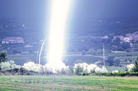
✅ ACCEPTED
🔍 Click to enlarge
Criteria met 100%.
✅ Strengths:
- Rare image of outstanding visual quality
- Multiple upward leaders
- Close-range shot
- Main channel overexposed, but not an issue
 ✅ ACCEPTED
🔍 Click to enlarge
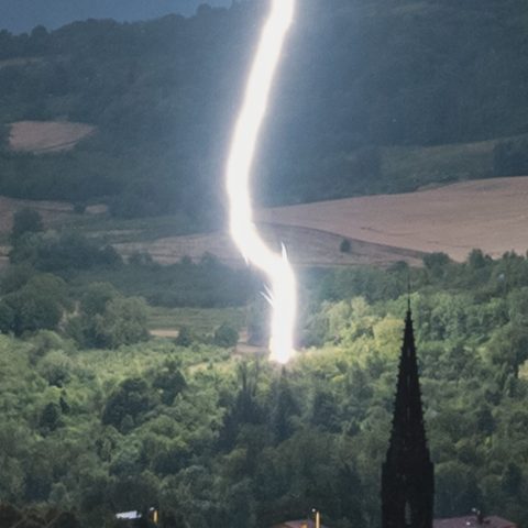
✅ ACCEPTED
🔍 Click to enlarge
Impact on vegetation
✅ Strengths:
- Zoom quality/phenomena balance
- Upward leaders
- Slight highlights reduction on the channel
- Dry air zone
 ❌ REJECTED
🔍 Click to enlarge
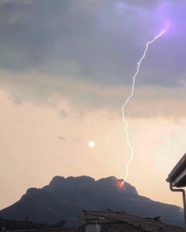
❌ REJECTED
🔍 Click to enlarge
Unidentifiable impact zone.
❌ Issues:
- Impact zone too blurry or invisible
- Excessive shooting distance
- Despite the colour at the impact point, it is difficult to draw precise conclusions.
 ❌ REJECTED
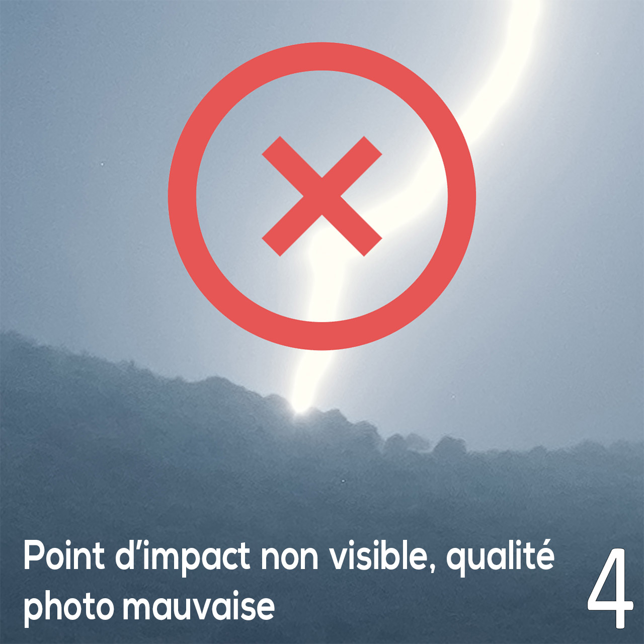
🔍 Click to enlarge
❌ REJECTED
🔍 Click to enlarge
No visible impact
❌ Issues:
- No distinguishing feature
- Falls behind the hill
- Insufficient quality
- Heavy rain reduces visibility
💬 Discord – Pre‑submission validation
If you have doubts about your cropped photo's compliance with quality criteria, post it on 💬 Discord in the "photo avant soumission" channel for validation.
This preventive approach avoids rejections and gives you advice on improving your crops before official submission. The community can also help identify remarkable phenomena (Power Flash, rock propagation, corona effect, upward leaders) you might not have noticed.
Discover the map
Responsive interface adapted to all devices (PC, mobile, tablet) with smooth navigation and advanced features:
FulguPédia: International collaborative resource
This is a major addition in V2 that I wanted to implement from V1, but the workload was heavy. We are now finally approaching my original vision for Fulgur'Zone: a space that brings together photographic evidence without geographical restrictions, and a resources section centralising everything related to lightning in one place. All through open contribution.
News, exhibitions, equipment, documentaries, books, etc. Sometimes a stormy context rather than lightning itself is concerned — such contributions are also accepted. However, tornadoes, hailstones and wind damage have no place on Fulgur'Zone.
A temporary confidence vote helps validate contributions quickly without the team having to supervise each one. A high number of negative votes will automatically exclude a contribution classified as unreliable.
Resources are classified by sections and sub-sections. A filter system lets you focus on resources of interest or perform a targeted search. For the video section, YouTube channels must have storms and lightning/sprites as their primary theme, with a minimum of documentary and production quality.
👤 User Account
V2 finally brings the user account system, allowing you to better manage your points and information. The user space is your dashboard on Fulgur'Zone, centralising everything related to you: public identity, contribution tracking, activity history and settings.
Profile & identity
You can complete your profile to have your contributions clearly attributed and easily identifiable by the community. Public name, presentation, useful links — everything that facilitates recognition of your work.
Contributions, Favourites & validation
All your submissions are grouped in one place (impacts, supplements, tracks, fulgurpedia). You can see what is published, pending or reclassified, with quick access to the relevant content. You can also edit already-added points.
A history lets you track your important actions: additions, edits, moderation feedback, status changes. There is also a section for points you have added to favourites, available on the map/gallery/list.
Public Author Profile
The author profile is your public page on Fulgur'Zone, grouping your name or alias, a short bio, your equipment and main information. It will be displayed on each of your contributions. To appear on the author profiles page, you need an active account, a filled biography, at least 2 social networks, and at least 1 validated active point.
Preferences & notifications
Adjust your experience: followed categories, alert types. The goal is to stay informed about what truly matters without being overwhelmed.
Restrictions
Each point has a limit of 2 description edits per month, and each edit request goes through team validation. The author profile also has a limit of 2 edits per month, applying only to the bio and equipment used sections. Why these limits? Each text description is auto-translated via the DeepL API into 5 languages: French, English, Italian, Spanish and German. The free DeepL model currently suffices with 500,000 characters per month, but a small monthly limit has been put in place to moderate usage.
Photographers keep full copyright. Scientific and educational use only, no commercial use.